The ancient face of the world

A legend coming from a small Russian village in 2002 has put the entire human historical concept in serious difficulty, proposing to science those specters of the past which it has always tried to escape. A discovery that occurred on the slopes of the Ural Mountains would be indisputable proof of the existence of a civilization that appear on Earth much earlier then the Sumerian civilization and suddenly disappeared. If this statement is confirmed it would destroy every human certainty regarding what happened in the past.
When God designed the world on the map of millions of years
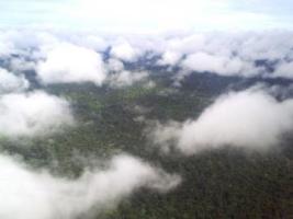
The leaden sky and low clouds envelop the Ural mountain range making it even more disturbing and inaccessible. The fog descends down to the slopes of these natural sculptures, heralding the Siberian desolation where the vestiges of peoples who have disappeared for hundreds of years chase each other across steppes and precipices full of memories.


The Urals run through western Russia like fossilized vertebrae of an ancient extinct animal in eras also erased by days, which here more than anywhere else, seem to flow each identical to the first. This is Russia, a crossroads of peoples, initially nomadic, who coexist in constant mystery, immersed in a tangle of past traditions and progressive ideologies characteristic of every people of Asia. Only in such a scenario could what we are about to document happen, a scientific discovery which, if confirmed, could subvert our notion of history in the future.
It's 11.20 am on a warm and sunny June morning. To be precise, it was Wednesday 5 June 2002, when the news released in Italy by the Ansa agency hit the major newspapers. The Internet, various teletexts and newspapers report the enigmatic news without providing much explanation and everything is resolved within a few hours. Everywhere it fades into a few skimpy lines that everyone expresses with the exact same words, in the absence of more detailed information. The academic world doesn't even notice it and the story is, predictably, forgotten.
But this rarely happens online and the inevitable controversy ended up involving Italy following the declarations reiterated during the Stargate program hosted by Roberto Giacobbo on the national television network La7.
But let's go in order.
Let's go back to June 5th when Ansa issues this statement:
Moscow - Russian scientists have announced that they have found a large mineral slab of artificial origin in the Ural region which they believe is 120 million years old and which would show a relief geographical map of the region. This was reported by Professor Aleksandr Chuvyrov, from the chemistry faculty of Bashkir University, in the Russian republic of Bashiri, according to whom the three-dimensional map could only have been created thanks to aerial surveys.
According to what Chuvyrov told ANSA, confirming information published by the newspaper Prava Ondine, the plate would be only a fragment of an enormous map of the entire Earth which, given the hypothesized age of the artefact, would upset all current knowledge.
Neanderthal man appeared on Earth 75,000 years ago. Chuvyrov, 53, said he did not want to suggest an extraterrestrial origin, but he calls the map inexplicable.
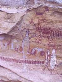
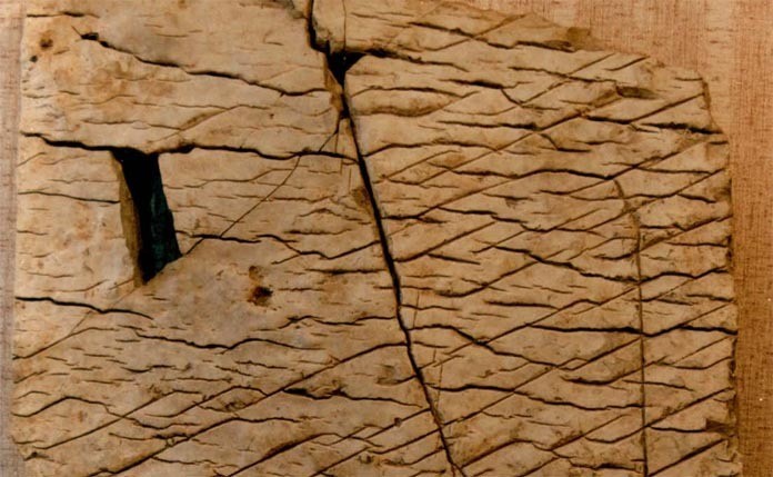
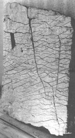
The slab, 148 centimeters high, 106 centimeters wide, 16 centimeters thick and weighing 1.5 tonnes, is made up of three overlapping layers of dolomite, diopside and porcelain. It was found in the town of Chandar, in the Urals, in 1999 but it has only been reported now. The map, as indicated by the Russian scientist, shows the identifiable ancient geography of the region, plus what appear to be engineering works with canal systems and dams. There are also inscriptions in a hieroglyphic-syllabic language of unknown origin.
At first, Russian scientists thought it could date back a few thousand years, but then fossil shells dating back between 50 and 120 million years ago were found embedded in the layers. The age would also be confirmed by the configuration of the rivers and canyons as they would have been tens of millions of years ago.
The map, according to Russian scientists, could not have been created by hand, but probably with high precision instruments and thanks to aerial surveys.

According to a local legend, an unknown number of slabs depicting large areas of the Earth must have been found in a small town at the foot of the Ural Mountains. In July 1999 one of these slabs was actually found under the floor of the porch of the house of a former local administration official. At the beginning, Russian scientists, whose intent since 1995 was to prove a Chinese migration towards the areas of Siberia and the Urals, thought that the inscriptions carved on the slab and not yet deciphered were an ancient language of Chinese origin. In fact, in many areas of Siberia and Russia in general, steles engraved in an ancient Cathayan language have been found in the past, as documented in Gavin Menzies' book 1421: China discovers America. However, these theories did not hold up for long, since none of the experts were able to read those signs. It is currently thought to be a hieroglyphic-syllabic language of unknown origin.
In the archives of the general government of the city of Ufa there are documents reporting the discovery, which occurred in the eighteenth century, of numerous stone slabs of curious appearance. Even the archaeologist A. Schmidt reported having observed rather unusual white plates.
Starting from these statements, the team of scientists led by Chuvyrov set off in search of the legendary plates, but without finding anything. Until 1998 Chuvyrov was convinced that it was just a legend. However, in 1999 a slab was reported to Chuvyrov by Chandar's former state official. The slab, weighing about a ton, was extracted with the utmost caution and was cleaned of the dirt. At this point, scientists were able to examine the find and recognized the morphology of Bashkiria. Chuvyrov states that over millions of years the geography of the area represented has not changed much; in fact, Russian and Chinese scholars following Chuvyrov established that the map described the Belya, Ufimka and Sutolka rivers, as well as several canyons in the Ural Mountains. Among the unknown signs engraved on the stone, clearly of artificial origin, the Russian professor is convinced that he has deciphered one, which, in his opinion, would indicate the latitude of the current city of Ufa.
The scholars established the age of the slab first through radiocarbon analysis of the layers, then by means of two molluscs found inside the porcelain layer with the aim of indicating two precise points. These molluscs are known to science as Navicopsina munitus and Ecculiomphalus princeps and became extinct 500 and 120 million years ago respectively. There is a widespread belief that the plate was created when the magnetic pole of the globe was located near the area of Franz Josef Land in the Barents Sea.
It is at this point that Chuvyrov, thanks to his partnership with a Chinese scientist, definitively abandons the idea of a possible historical-Chinese origin of the map.
Word of Chuvyrov
We now offer you the only interview given in Italy by Professor Aleksandr Chuvyrov on the Stargate Border Line program where the Russian scientist reiterated the statements made previously.

Interview:
I am very pleased to be here in the Stargate Borderline studio. This is the first time I have come to Italy to this studio and I thank Hera magazine for this. The fact is that this summer there was a huge discussion around my discovery throughout the world press. Many journalists and television editorial staff even think that I am simply a more or less fortunate invention of Russian journalists. Instead I am a living person and I am present here; I would like to tell you about my discovery.In a small village called Chandar which is not very far from a canyon in the Ural Mountains, more or less until a hundred years ago, according to legends, there existed 6 mysterious slabs which were thought to have disappeared. In 1998 and 1999 I organized seven expeditions and I also did helicopter reconnaissance to look for these plates and finally in 1999, on July 21st to be precise, I managed to find a plate of this kind exactly under the house of the oldest inhabitant of Chandar. We were incredibly amazed when we pulled up this plate and saw that it was practically an inscription, it was a three-dimensional map that depicted a part of the earth's surface. After that we brought this table to Ufa and organized a special laboratory and invited a whole series of specialists in various fields of science especially geologists, geographers, cartographers, philologists, physicists, mathematicians and experts in goods and materials technology.
From a first analysis we discovered that this stone contains cartographic information relating to the southern part of the Ural Mountains, therefore it is a map of the southern part of the Ural Mountains. I repeat, it is not a simple map but in three dimensions where all the mountains and all the rivers are indicated in their real appearance according to the measurements that are reported according to the scale. This scale is 1 to 1.1 which means 1 centimeter is one kilometer and one hundred meters.
After that we saw that the stone had dimensions of 1.48 by 1.06 by 16 centimeters thick. This stone is made of three layers, the first is dolomite, the second is diopsite and the third is a porcelain cover. The porcelain covering was made after the relief had been made, i.e. after the cuts had been made on the stone. I must point out to you that the diopside layer was made using nanotechnology, this is because the hardness of diopsite is similar to that of corundum and otherwise the subsequent material would not have been able to be bonded.
We see some canals: there are 12,000 kilometers of canals. The canals are 500 meters wide and 300 meters deep. Nowadays we cannot imagine exactly who could have done this work but in fact I can say that it is currently the only object we have found of this type. It has no analogues in the world and we did an expertize of the porcelain and realized that it was an unknown type of porcelain also including unknown inscriptions.
We noticed that on the left side of the map there is a model of the solar system and from this detail we can try to determine the earliest date when they made this map. We can at least say that the map was made more than 13,000 years ago. There are other indirect data that show the age of the map. I want to underline that these are indirect data.
For example, there are paleontological data that allow us to give an age of 120 million years.
I would like to point out that to create some of the conventional signs in the map, molluscs were inserted which disappeared more than 60 million years ago. We did a very careful analysis of these molluscs which showed us that they were walled in the map when they were still alive. So based on this data we can estimate the age of the map. Analysis of the map edges shows that there must be several maps. There doesn't have to be just one, and it's possible that it's either an all-Earth map or a large part of the Earth. We want to recover the second and the third plate. I will make sure that the Stargate Borderline transmission always knows exactly what is happening.
I will keep you informed.
Criticisms from the Web
While the scientific world was preparing to immediately turn the page, forgetting what had happened, an increasingly thick cloud of dust was gathering on the internet. The war between skeptics and believers has obviously led to nothing other than a deepening of the enigmatic story, however it has raised legitimate questions about the Russian professor's statements.
In his online report Map of the creator, a global hoax Silvio Sosio from the pages of corriere.fantascienza.com of 10 June 2002 bluntly attacks the work of scientists and journalists, wondering how the former could have been blind to Chuvyrov's erroneous statements, and how the latter imitated each other by reporting identical news without attempting to inform themselves. Sensationalism first of all...
The questions that Sosio asks himself based (in turn) on the research work of others, are in any case logical. Why did a university professor like Chuvyrov, despite having a degree in chemistry, make a colossal error by stating that Neanderthal man appeared on Earth 75,000 years ago, when the same dubious archaeologists conventionally estimate an age of 300,000 years for the oldest fossils? And again, how can Chuvyrov recognize in the folds of a stone slab areas of Russia that certainly 120 million years ago were completely different from how they appear today? In any case, the skeptical journalist does not provide any answer, referring to articles that appeared on the internet some time before which apparently are all similar to each other, one being the source of the other. Perhaps because such questions would be better to ask Chuvyrov himself.
Russian scientists are convinced that the Chandar plate is just one of the 348 fragments that should make up a map of the entire planet. It follows that the complete map would have dimensions of approximately 340x340 meters. Why would the creator have used nanotechnology and its unknown and highly advanced science to create a work of mammoth dimensions and certainly not very functional? Why make a slab of three exceptionally hard and heavy layers simply to describe the geology of an area? Even if all this is possible, what purpose was this enormous map created?
Chuvyrov's studies have highlighted the accuracy of the geographical reliefs represented, without however providing an explanation of the usefulness of having a once intact map of such dimensions. But who could ever use such an artifact? Certainly not even giants.