The Piri Reis map and other mysterious maps
How were people capable of tracing the contours of the Antarctica centuries before it was officially discovered without the aid of indications provided by artificial satellites? The question affects history and science at the same time, even if the "official" scholars do not want to talk about the "maps of the ancient sea kings"
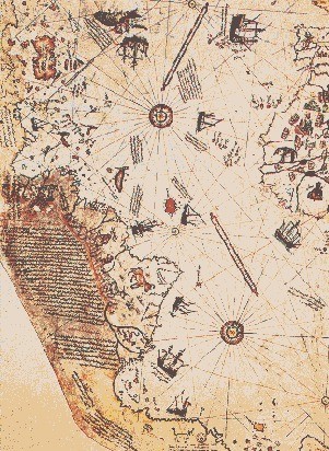

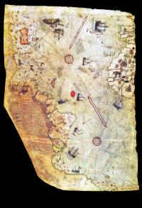
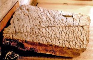
On November 9, 1929, the director of the Turkish national museums, Halil Etem Eldem, discovered, while taking an inventory of what was preserved in the famous Topkapi, the ancient imperial palace in Istanbul used as a museum, a fragment of a geographical map of the Earth with 24 inscriptions, written in Turkish. One of the inscriptions specifies the identity of the author: "This map was drawn by Piri Re'is Ibn Aji Mehmed, nephew of Kemal Re'is, in Gelibolu (Gallipoli) in the month of Moharrem of year 919 (between 9 March and 7 April 1513)".
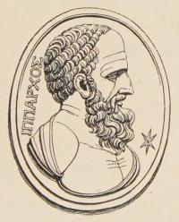
The character mentioned, literally, as "Piri, admiral, son of the pilgrim Mehmed" is better known by the name of Piri Reis. Descended from a family of illustrious Turkish navigators, he was appointed admiral after participating in the battles of Modon and Lepanto and then elevated to the rank of commander-in-chief of the Egyptian navy.
Erroneously considered a pirate by some European historians, Admiral Reis was, in reality, a cultured and intelligent navigator and leader. Knowing and speaking Greek, Spanish, Portuguese and Italian perfectly, he had the opportunity to consult, as a whole, the maps existing at that time. He was thus able to draw up, by making a synthesis of all the geographical knowledge of his time, two maps of the world, one in 1513 (the one that interests us), the other in 1528. Author of poems and various works, he is above all known to navigators of his country for the "Kitabi Bahriye" (The Book of the Navy), a volume of memoirs which is a real treatise on navigation in the waters of the Mediterranean, including 207 maps drawn by Piri Reis himself. Dealing with various topics, the "Kitabi Bahriye" establishes the historical truth about Columbus' adventure, telling us how the Genoese navigator did not discover America, but only rediscovered it, already knowing its existence before having been there and heading there to sure shot. This is confirmed by a letter from Bartolomeo, Christopher's brother.
But where did the latter get these notions? From a document dating back to the time of Alexander the Great, the Turkish admiral asserts, counting among those who landed on the other side of the Atlantic the Vikings, San Brendan, the Portuguese Nicolas Giuvan, Antonio the Genoese and others.
Thus writes Piri Reis in the chapter dedicated to the "Western Sea" (the name given for a long time to the Atlantic Ocean):
"An infidel, named Columbus, originally from Genoa, was the one who discovered those lands. It had fallen into the hands of the aforementioned a book, and he read in it that beyond the Western Sea, to the west, there were coasts and islands, and metals and precious stones of all kinds."
Further on, Piri Reis states that he had stayed for a long time with a sailor from Columbus, captured by his uncle Kemal Reis: he, having become a slave, confessed to possessing a map that had been given to him by the Genoese navigator and which would later be used partially by Piri Reis for the drafting of his maps. It is again the slave who provides the admiral with very interesting information about the inhabitants of the discovered lands:
"The inhabitants of this island saw that they ran no danger from our ships: so, having caught some fish, they brought it to us with their their boats. The Spaniards were delighted and gave the natives small glass objects, because Columbus had read in his book that those people liked them very much."
As for his documentation, Reis writes:
"This section shows how the map was drawn. Currently no one has a map like this, drawn and now completed by me. I took it from about twenty maps and from the "Mappe Mundi" (maps drawn in the time of Alexander, lord of the Two Horns, showing the inhabited parts of the world: the Arabs call them "Djaferye"); from eight djaferye of this kind and from an Arabic map of the Hind; from recently drawn maps from four Portuguese, showing the countries of Hind, Sind and China drawn geometrically; and from a map of the western region drawn by Columbus. By reducing them all to the same scale, I arrived at the final form: the present map is as correct and as safe for the seven seas as the chart of our countries is deemed correct and safe by sailors."
What did Piri Reis mean by "cards drawn in Alexander's time"? With this expression did he mean maps drawn up by contemporaries of the great conqueror or was he referring to those of Alexandria, preserved in the most famous library of the ancient world and perhaps miraculously escaped the fire ordered by Julius Caesar?
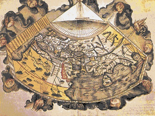
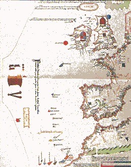
No cartographer of antiquity, from Eratosthenes (275?-194 BC) to Claudius Ptolemy (2nd century AD), to Marino di Tiro (also of the 2nd century), to Pomponius Mela (1st century), has represented, in the works that have arrived, America and Antarctica. Instead, a first look at the color map of Piri reis, made on a gazelle skin measuring 85x60 centimetres, allows us to see that it includes the western coasts of Africa and Europe, from Cape Palmas to Brest, including the islands in the 'North Atlantic and some of the South Atlantic, Cuba and the Caribbean islands, the Atlantic coast of South America, from Cape Frio up north, up to the Amazon, and the island of Maracà, two mysterious and unknown islands, one of which it is called Antilla, while the other extends into an area in which, today, only the very small rocky islets of Saint-Pierre and Saint-Paul exist, a part of the Andes chain, the lower eastern coast of South America, from Bahia Blanca to Cape Horn, the South Shetland Islands, the Falkland Islands, a part of the Antarctic continent, including Queen Maud Land.
Among the numerous illustrations and miniatures that adorn this map, a llama and a puma are reproduced in the part depicting South America.

If, among the navigating precursors of Columbus, Piri Reis mentions the Vikings, San Brendan, Nicolas Giuvan, Antonio the Genoese and others, it is however well established that they only knew a part of North America and were ignorant of the South American coast as a whole. For his part, Columbus had only explored part of the Caribbean Sea and the coasts of Central America. Therefore it cannot have been his former sailor who became a slave of the Turks who informed the admiral in such a precise and complete way. By way of example, it can be said that cartographers of his time, such as Jean Severs or Lopa Hamem, still confused North America with Central America, or gave the image of a land very different from the one we know. Furthermore, we had to wait for the Conquistadore's expeditions to learn about the existence of the Andes, pumas and llamas.
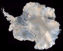
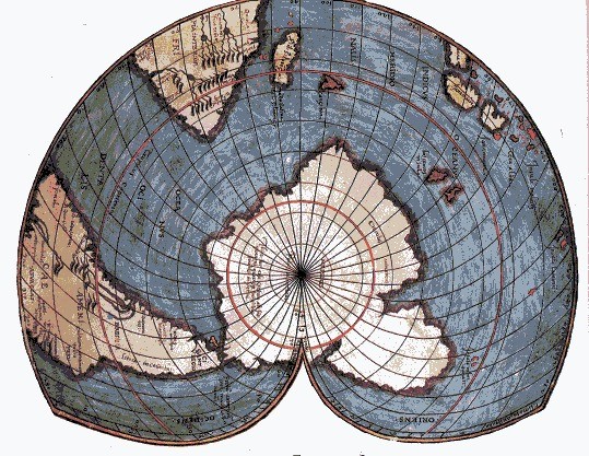
As for the Antarctic continent, it is represented as free from ice: the area was "rediscovered" only at the beginning of the 19th century, and only in 1958, during the International Geophysical Year, was the route of its original coasts established, probing under the ice. If this map has not reached us complete (most of the northern hemisphere and almost entirely the eastern sector are missing), the existing part presents a series of enigmas, starting from those linked to its creation.
Shortly after the discovery, the Piri Reis map was examined by scholars of some renown, such as the German professors Kahle and Deischmann, but then silence fell on it: the scientists hastily came to the conclusion that "it was not a map of Christopher Columbus"! It now seems clear to us how it "disturbed", calling into question too many universally accepted principles, posing more problems than it solved, even making the already uncertain foundations of the history of humanity and its evolution go beyond.
Due to a series of circumstances, in 1956 the map attracted the attention of scholars free from preconceptions. Offered by a Turkish Navy officer to the Hydrographic Office of the US Navy, a copy was transmitted to a talented cartographer, M. Walters, who passed it to an ethnographer friend of him who was passionate about ancient cartography, Captain Arlington H. Mallery. The latter had begun several years ago to dedicate himself to the study of maps of North America and Greenland drawn by the Vikings. Having examined the map, he immediately observed that its southern part represented islands and bays of the Antarctic coast now hidden by the ice, and he was the first to affirm that someone must have made such surveys before the appearance of the ice, therefore in a period in which the Antarctica was still accessible to man and its resources still exploitable: this justified the interest in the southern lands, which had arisen at least six thousand years earlier.
Of course, such declarations unleashed the wrath and sarcasm of geographers, but there were those, such as the seismologist Daniel Linean, director of the Weston observatory of Boston College, and Father Heyden, director of the observatory of Georgetown University, who took the Mallery's allegations seriously. It were these scholars who pushed Professor Charles Hapgood, geographer and geologist, holder of the chair of history of science at Keene State College of the University of New Hampshire, to dedicate himself to the study of what was defined "the most scandalous cartographic and historical hypothesis of the time."
Hapgood said he was convinced, together with his collaborators, that some navigation maps that appeared in antiquity and the Middle Ages were much more precise than those originally drawn in the same period and that therefore based on older documents, drawn up by cartographers who possessed much broader and more precise knowledge.
Now, there are those who, being (reluctantly perhaps) forced to deal with the Piri Reis map, wanted to find errors in it to contradict the supporters of its authenticity. The first objection was that relating to the geographical coordinates, which do not correspond to modern ones, but seem to radiate starting from the center like the spokes of a wheel, or rather, those of a compass. The explanation is not difficult: they were drawn not to guide the navigator, but to facilitate the work of the cartographer. There are some inaccuracies in the Turkish admiral's maps, but they are obvious and demonstrate how Piri Reis based himself on excellent ancient maps and on others that were less good because they resulted from the incorrect copying of certain details from previous documents. As time passes portolan charts (nautical charts) become more and more approximate: they ultimately served sailors only to allow them to go from one port to another (hence the name) without the risk of making too many mistakes.

As for Piri Reis, here are some examples. The Amazon River is drawn twice: the second time the admiral represents completely correctly the island of Marajo, discovered only in 1543. There are 900 miles of coastline missing between Cape Frio and Bahia Blanca, but the Falklands (discovered in 1592) are perfectly reproduced. The Drake Strait, which separates Cape Horn from the Antarctic continent, is not seen on the map, but the Shetland Islands of the southern hemisphere appear.
In Antarctica, the Palmer Peninsula, Queen Maud Land and numerous subglacial mountain peaks off the coast are easily visible, identified as such by the Norwegian-Swedish-British Antarctic Expedition in 1954. Curious is the fact that Admiral only drew the island of Cuba in half, representing the western part in the form of a group of islets. Professor Hapgood clarified the mystery: this part was, in ancient times, completely submerged.
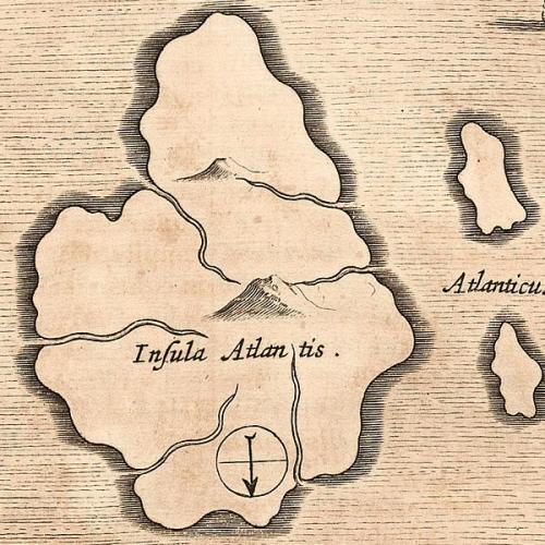
Another element that testifies the multi-millennial age of some fragments used by the Turkish cartographer is the mysterious island of considerable size located in the Atlantic, where today the islets of Saint-Pierre and Saint-Paul rise, called "Antilla". Hapgood believes it is an "artificial" reproduction of the fabulous Atlantis, but others persons are inclined to believe in a more or less faithful representation of the last remaining strip of land that emerged after the submersion of the continent (or rather, of the vast archipelago) which disappeared into the abyss over ten thousand years ago.
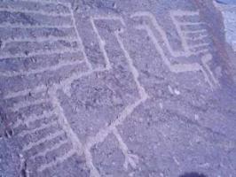
If the Piri Reis map is astonishing, it is certainly not the only one in the history of cartography. We begin with a map of China engraved on stone in 1137. The interior of the great territory is depicted with extraordinary precision, except for slight differences regarding the Yellow River. But we know how much rivers can change the location of their bed over the course of centuries or millennia. As regards the projection method, this map, like others, is based on spherical trigonometry: everything tends to prove that the civilization established at the beginning was a world civilization.

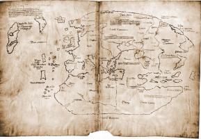
In 1380 the Venetian brothers Niccolò and Antonio Zeno possessed a very ancient map that showed Greenland without the ice cap. This map would have allowed them to travel the Nordic seas, discovering many islands. The geography of that map agrees perfectly with the discoveries made by Paul-Emile Victor's French expedition from 1947 to 1949.
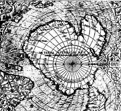
The greatest details of the Scandinavian coasts come to us from the map of the Italian Andrea Benincasa (1508) while to find the first representation of Australia (discovered in the early 1600s) we have to wait a couple of years: we see Australia in the Reinel's map (1510), with part of the Indian Ocean. One of the biggest surprises, however, is given by the map of Oronteus Finaeus (1532), which presents Antarctica in all its completeness. It is so precise as to mark the South Pole exactly and to be superimposable to a modern day map.

Hadji Ahmed also shows us Antarctica, but with large projection errors, while he perfectly traces the profile of the American coasts (1559), including an Alaska-Siberia land bridge that existed only during the ice age.

And we come, with Jacques Victoor, to the pilot book of Jehudi Ibn Ben Zara of Alexandria in Egypt.
"It is the best of all, but it presents three anomalies: the mouth of the Guadalquivir (currently a delta) is depicted as a bay, the Aegean Sea is full of islands, while today it has a much smaller number; finally, Ibn Ben Zara draws glaciers in Ireland and England. These three details suggest the idea that the original map dates back to the end of the last glaciation"
Thus the scholar writes and concludes:
"A civilization of global scope, not yet identified, should therefore have existed 6 to 10 thousand years ago. This civilization knew the volume of the Earth, as well as its complete geography. It was capable of calculate longitudes and latitudes precisely and applied plane trigonometry and spherical trigonometry to cartography.It was therefore a brilliant civilization, equipped with important technical means. The papers that survived the disappearance of this civilization may very well have ended up in the libraries of Alexandria in Egypt and in that of Carthage, both of which were later destroyed by fire. The Phoenicians and the geographers of Alexandria then used this material, then transposing it with the modest means of the time and botching the job. The resulting pilot books are scattered throughout the world. It cannot therefore be surprising that Piri Reis, Christopher Columbus and others have come into possession of such precious documents."

Even in relation to lands closer to us, however, the knowledge of the ancients is such as to leave us amazed. Below, the opinion of some scholars.
"Ptolemy's Almagest"
writes Andrew Thomas,
"reports all the geographical data known in the 2nd century AD. The Egyptian astronomer describes equatorial Africa, the upper reaches of the Nile and the mountain ranges in the heart of Africa itself. It is clear that this scientist knew much more than the cartographers of the first half of the nineteenth century knew.When the exploration of Central Africa in the last century revealed the existence of the snow-capped ranges in question, and the geographical reports were presented to the Royal Geographical Society of London, the learned members of the institute found which is very funny. Snow on the equator? Nonsense!"
All nonsense, of course. Our ancestors were evidently gifted with crazy imaginations.
Dr. Livio C. Stecchini states:
"I was fortunate enough to come across well-known but neglected Egyptian documents, which prove that by the time of the First Dynasty (5,000 BC) the Egyptians themselves had accurately measured the latitude and longitude of all major points of the course of the Nile, from the equator to the Mediterranean. Following this first trace, I discovered a series of texts (all preceding the beginnings of Greek science) which, starting from Egypt, provided positional data including most of the "old world", from the Congo and Zambezi rivers to the Norwegian coast, from the Gulf of Guinea to Indonesia, including incredible places such as Swiss peaks and central Russian road junctions. Such data is so precise that it is almost a source of discomfort. I have tried desperately to find errors, but I didn't find any, I couldn't find an error in latitude greater than 1' or an error in longitude greater than 5' in ten degrees"
We conclude with Arlington Mallery:
"At the time in which the maps were drawn up, not only must there have been explorers, but also particularly competent and organized hydrographic technicians, since it is not possible to draw maps of continents or large territories like America if one is alone or even a small group. Experts who know both astronomy and the methods necessary for surveys are needed. It is impossible to understand how those maps could have been drawn without the aid of aviation. Furthermore, the longitudes are absolutely exact, as we have only been able to calculate them for two centuries".
Wanting to reach definitive conclusions from his study of the Piri Reis map, providing worldwide evidence of a sophisticated map system dating back to a pre-Greek era, Hapgood began examining a large number of ancient maps from the East and West. Always resorting to the system already experimented with his students to examine the Turkish admiral's document, he applied it to Dulcert's pilot book of 1339, "the most exact map among those discovered", as he stated, and the one that he considered closest to the mysterious "regulatory pilot book", which would serve as a model for many medieval and Renaissance pilot books.
Let's not forget that the Piri Reis map did not reach us intact and that the Mediterranean basin, Europe, Asia and a large part of Africa are missing. Hapgood hoped to find the missing parts, or at least, a similar map. His dreams came true when he was able to consult De Canerio's map of 1502, which accurately represents all of Africa, the Mediterranean and a part of Asia. Another Turkish map, that of Hadji Hhmed, from 1559, does not fail to surprise. The route of the coasts of North America is very interesting and it is difficult to believe that it is the result of observations carried out in the 16th century.
The same numerous surprises were reserved for Hapgood by the ancient maps of the Far East and Oceania. That of the Portuguese Jorge Reinel presents the first outline of an immense island in the point where Australia is located, in an era in which this land was completely unknown.

The in-depth study of Yu Chi-fu's Chinese map, called "Map of the Tracks of Yu the Great", which is believed to have been engraved on stone in 1137, although supposedly older, confirmed the accuracy of Hapgood's conclusions by providing the verification of Mallery's hypotheses: as the scholar wrote,
"it provides proof of the existence, in very remote times, of a world civilization whose cartographers have virtually drawn the contours of the entire globe at a uniform technological level, with the same methods, the same mathematical knowledge and, probably, the same tools".
It could not be clearer or more precise, and the evidence adduced by Hapgood seems decisive, even if it deals a serious blow to our beliefs about progress and continuity. The evidence cannot be denied: there should have existed, in a very distant past, a civilization which, thanks to a very high scientific and technological level, would have had the possibility of drawing much more exact and complete maps than those which have come down to us from the Middle Ages. Mysteriously this civilization disappeared, but left to posterity documents which, having come into possession of some famous libraries, managed to escape destruction. Various people used these fragments of the highest level and reworked them with their limited means, integrating them with their limited knowledge.
This is the origin of those "scandalous papers" that allowed Hapgood, Mallery and their collaborators to solve an enigma whose solution, in reality, poses an even more disturbing question. This disappeared civilisation, which Hapgood defines as "world culture", had reached a scientific level, if not higher, at least equal to that of 19th century Europe: this is demonstrated by maps and travels, a well-structured government, a society with imperialistic aims, or at least, favoring commercial exchanges. We must therefore abandon the idea of the linear and progressive development of civilizations. As we see today, societies at different levels of development can coexist. It may be that, 20,000 years ago, Paleolithic tribes and more advanced cultures coexisted and decided to discover the planet Earth.
Every culture has within itself the seed of its destruction, which ends up overwhelming it. Every civilization seems to develop until it is able to create the means to self-destruct. The more a culture has evolved, the easier its destruction will be and it will leave fewer traces.
The world of scientific knowledge of the ancients, in turn, was destroyed by the fanaticism of men. The same thing happened to everything that could have damaged various religions.
It is therefore not impossible that even the faintest memory of a great civilization has vanished.